HOME | DD
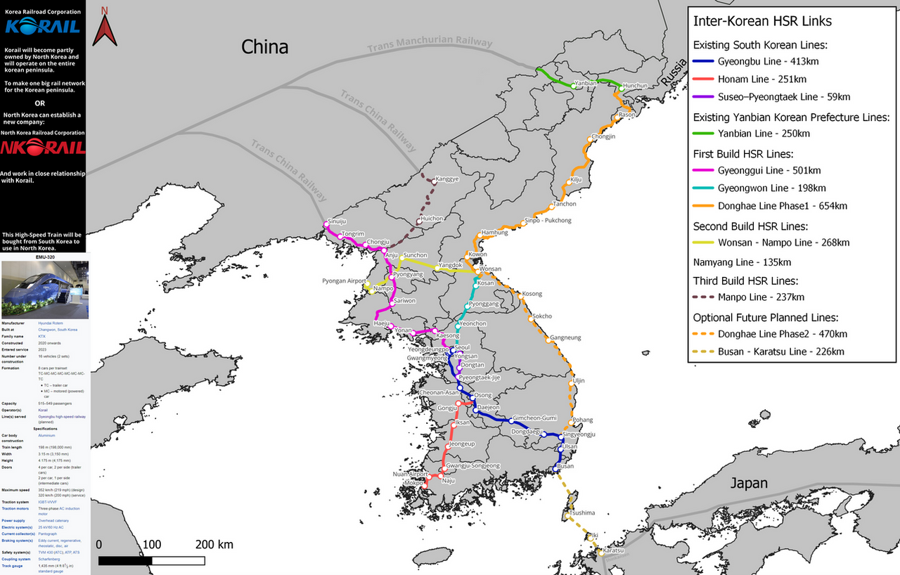
 ShadowESH — Inter-Korean HSR links

#hsr #map #northkorea #rail #korea #korean #railroad #railway #highspeedrail
Published: 2022-12-31 17:08:06 +0000 UTC; Views: 1448; Favourites: 12; Downloads: 8
Redirect to original
Description
Here is a map of the future High-Speed Rail of North Korea after the events of my "Plan for the founding of the new North Korea":www.deviantart.com/shadowesh/a…
Which distance high speed trains are a better option than airplanes?:
Trains are faster for journeys up to 620km (track distance).
You’ll save the most time taking the Eurostar from London to Paris saving 50 minutes compared to flying.
Past research shows that HSR can typically replace flights up to 1000 km in distance,
and they are most competitive for trips under 700 or 800 km.
The new North Korean HSR will use the "LTE-R" Railway Communication system.
UPDATE 01/03/2023: Territory Modification
After a review of the territory of the new Republic of North Korea.
I removed the "Dunhua county" located in the "Yanbian Korean Autonomous Prefecture".
Instead of the whole prefecture becoming Republic of North Korean territory, "Dunhua county" will remain Chinese.
Instead parts of "Fusong" and "Linjiang" (next "Changbai Korean Autonomous County"), will be given to North Korea.
The reason of this modification of the Chinese, North korea agreement.
(If you are like= what agreement? Then read "Plan for the founding of the new North Korea" on my profile.)
Is the following:
"Dunhua" is a major highway intersection (G333,G201,G302,G334,G11,G12).
If "Dunhua" became North Korean the this will cause a big problem for traffic and border control will be a mess.
Chinese will have to cross borders constantly.
For example, if a chinese citizen wants to go from "Baishan"(china) to
"Mudanjiang" (china). Then they will need to go through north korean territory.
This will be a headache for the Chinese and north koreans.
So "Dunhua county" will remain chinese!


