HOME | DD
 Lytrigian — Tales of the Tempest: Map
Published: 2008-05-10 22:57:19 +0000 UTC; Views: 5569; Favourites: 9; Downloads: 637
Redirect to original
Description
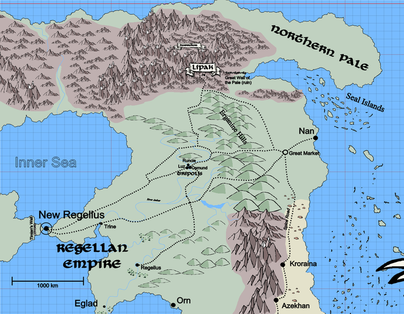
You'll have to download this to see it best.This should help some with the geography for Tales of the Tempest. It's still pretty rough, and will get filled in more as things progress.
Lipak, Kitaro's home, is in the southern portion of the large northern mountain range near where the Erganine Hills run into it. For reference it's at about 58° north latitude, about the same as the southern tip of Norway. (That darker red line near the top of the map is the Arctic Circle.)
The Regellan Empire now occupies the relatively small territory near its coast. It extends far enough inland to encompass old Regellus, but not much further. Its southern border is a line extending from the hills just south of old Regellus out to the coast, and its northern border is that point of land along the coast about 800 km northeast of New Regellus. It's still a very large territory compared to most of the states that have sprung up on the continent in recent years, but it's much reduced from its former extent. It once controlled all the land east of the Inner Sea to the opposite coast, as far north as Lipak and the Great Wall of the Pale, and as far south as the edge of the eastern desert. West of the mountains it encompassed Orn and the entire coast of the gulf on which it sits. It also possessed considerable territory west of New Regellus, but now has only the small portion behind the long defensive wall opposite the City.
The Tripolis, Tamarick's home, comprises the three cities of Luz, Runcie, and Osmund together with the territory for about 200 miles round about and is near the center of the map.
The village of North Bend where Along the Forest Road takes place is about 300 miles north of the Tripolis, but is too small to mark at this scale.
The Saevian Sea is the sea to the east. Only the westernmost of the Ten Thousand Islands are visible here, and this far from the main islands are more or less independent of the Hachido government.
Map created with Fractal Mapper 8 from NBOS Software .
Related content


Comments: 6

Looks good  (Smile)")
👍: 0 ⏩: 1

Thanks! It's pretty rudimentary. I'd anticipated filling it in as my stories progressed, but they've been stalled for a few years now. Hopefully I can get them going again, and then with more of a map.
For creating fantasy lands, there's probably no better software. Being able to automatically create "jaggy" coastlines and river courses without having to lay down every individual line segment is a huge time saver.
👍: 0 ⏩: 1
Ive been playing around with it quite a bit latley, and it is so much easier to create maps with. Ive managed to do a world map, but im still trying to work out how to create Regions within countries, easily that is
👍: 0 ⏩: 0
It isn't much, but thank you. There would be more to it if I were writing more diligently.
👍: 0 ⏩: 1

Lol okay. Dont worry, still got plenty of time
👍: 0 ⏩: 0